Monts de Vaucluse

Vaucluse Natural place, Les Monts de Vaucluse, History, Geography Tourism
The Vaucluse mountains are a mountain range of the Southern Alps, in the departments of Vaucluse and Alpes-de-Haute-Provence, in Provence.
The common set on the Monts de Vaucluse are Roque sur Pernes , Lagnes , Le Beaucet , Lioux , L'Isle-sur-la-Sorgue , Méthamis , Walls , Oppedette,Pernes-les-Fontaines , Roussillon , Rustrel , Saint-Didier , but we must also add various municipalities or parts of municipalities such as Aurel , Le Beaucet , Monieux , Saint-Christol , Sault ...
The Massif des Monts de Vaucluse is oriented east-west, bounded on the north by the Toulourenc and Jabron, south by the Calavon valley and beyond the Luberon to the west and northwest by the plain of Comtat Venaissin and east almost to the Durance.
The northern part is formed by the links of the Mont Ventoux - culminating with the massive 1,912 meters above sea level - and Lure (1827 m), separated by the Albion Plateau (1393 m).
The eastern part is a mid-altitude plateau that ranges between 800 and 1,000 meters and peaks in signal St. Peter in 1256 meters altitude.
The western part consists of members, since the region Sault until towards the plain. The altitude varies between 300 m and 1000 m. The Dentelles (755 m) west of the Mont Ventoux ,
The Luberon Regional Nature Park extends to the southern part of the massif.
Geology and Hydrography Combe de Lioux , parallel to that of Vaumale. The massif is formed of limestone from the Mesozoic era, often permeable.The water sinks into the rock, creating underground networks (karst system), standing at low points as the Fontaine-de-Vaucluse. There are numerous sinkholes: the Aven Souffleur to Saiint-Christol (795 meters ), that of Caladaïre near Montsalier (667 meters), and the Aven Autran (647 meters) to Saint Christol, are among the deepest
In Vaucluse, lleur area is 72,660 ha2 with an afforestation rate of 40%, the Vaucluse mountains are a tray with a low density outside the villages and hamlets.
The first traces date back to the Neolithic. The territory is occupied by several Celtic-Ligurian tribes. Many oppidums on the foothills of massif.on also notes the use of the Fontaine de Vaucluse by the Romans.
Until the middle of the third century, the large regional industry is that of iron with rich soils Roussillon, Gargas, Rustrel, etc.
There are craft furnaces Fontaine-de-Vaucluse in Simiane-la-Rotonde. In the eleventh century, there is the creation of "Castrum" (Fortifications perched around which have developed villages) The arrival of the Popes in Avignon introduced the cultivation of silk in the region. Gradually develop the culture of the mulberry tree, whose leaves are food for worms.
Religious wars affect some villages south of the massive buttresses. Cabrières-d'Avignon will turn up and shaved in the massacre of the Vaudois in Luberon.
Between 1720 and 1722 the papal troops tried to prevent the plague from Marseille to invade the Papal States by building the plague wall south of the Monts de Vaucluse: Lagnes , Cabrières-d'Avignon-en ,Murs .
On August 12, 1793 is created the Vaucluse department , consisting of the districts of Avignon and Carpentras , but also those of Orange and Apt , who belonged to the Bouches-du-Rhône and the Township Sault , which belonged to the Lower Alps.
Resistance came early during the Second World War and the German occupation aided by the rugged terrain. On 11 November 1948, several municipalities of the Monts de Vaucluse, as Gordes (Mention in the division - silver star) or Sault (Mention in the corps - star vermeil) receive Military Cross.
April 1965 because of its low population density and its soil, the Plateau d'Albion is chosen for the siting of nuclear silos. Only 18 elevators and 2 fire control stations (PCT) will be built and the air base (BA200).
September 1996, President Jacques Chirac announced the closure and dismantling of the facilities of Albion, due to the evolution of European geostrategy (fall of the Eastern bloc) and the Missile aging
Well known for its lavender, Plateau's economy is mainly oriented towards agriculture (lavender, spelled and other grains, goat farming ...)
and tourism (green camping, hiking, mountain biking, caving, Road lavender. ..).
Agriculture
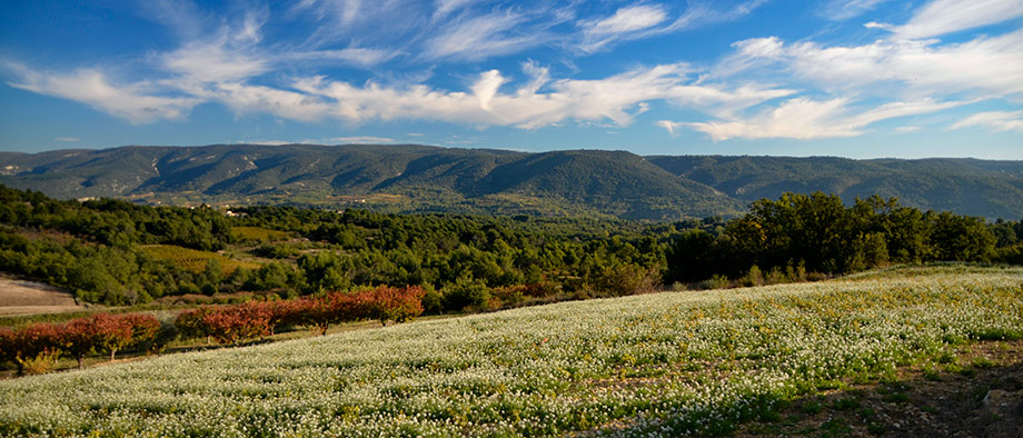
View of Mount Ventoux from the lavender fields of the Vaucluse mountains.
Ceriseraies and vineyards of Vaucluse mountains.
The altitude and the lack of water make it a very favorable area for many cultures. The afforestation rate is 67%, large moors and pastoral formations occupy 13% of the surface.
In the cultivated areas, there are lavender, spelled, wheat, cherries.
It is a region of sheep, goat and pig. Ventoux pork is a quality label, created in 1998, gathering the outdoor pig farmers around Mount Ventoux.
The pigs of this sector are raised outdoors, at an altitude of 800 to 1000 m. The production area is located east of Sault (50 km zone), in the mountains of Vaucluse, south of Mount Ventoux.
The animals have space field, about 100 to 110 m2 per individual . They are fed by a varied, more than 70% composed of cereals, supplemented by legumes.
Using products growth factors, or animal products are prohibited by the production chain charter
Two sites are classified or being classified:
Rocks and valleys of the Monts de Vaucluse
The first site touches the northwest of the town of Gordes in a first area, the northeast and south walls in a second and east of Lioux and West St. Saturnin-les-Apt his neighbor in a third area.
It covers a total area of 1738 ha and lies between 276 and 874 meters. The surface of this website intersects the Special Protection Area of the Petit Luberon Massif.
The site consists of heathland, scrub, recruits, and maquis scrubland, Phrygana to 30%, non-coniferous evergreen forests also for 30% of dry grasslands and steppes for 20% and inland rocks, scree, inland dunes, snow or permanent ice to 20% also.
The composition of its natural habitat is divided mainly between forests Quercus ilex and Quercus rotundifolia (30%), Mediterranean pine forests with endemic Mesogean pine (15%) and substeppiques course grasses and annuals of the Thero-Brachypodietea (8% ), the remainder being consistently below 3%.
Nesque
Located on Méthamis communes, Blauvac and Monieux, it covers a total area of 1,233 hectares and lies between 281 and 859 meters.
The site consists mainly of: deciduous forests 50%, Heath, Scrub, recruits, Maquis and Garrigues, Phrygana for 20% and domestic Rocks,
Scree, inland dunes,
It may be noted in the composition of its natural habitat: "Forests Quercus ilex and Quercus rotundifolia" (37%), "Western Mediterranean and thermophilous scree" (8%)
and "forests of slopes, screes and ravines Tilio- Acerion "(5%), the remainder being typically lower than 5%.
The Aiguiers example of a Aiguier sheltered under a borie in Saint-Jean-de-Sault
The territory is rich of buildings whose main material is stone: Bories, aiguiers, walls, etc.
There northeast of Saint-Saturnin-lès-Apt, a "country of aiguiers," so named because it once had many farms to a single point water cistern dug into the limestone rock and fed
by rainwater streamings by a water recovery system (catchment area in technical language). But aiguiers of extension area is not limited to this town of Monts de Vaucluse.
We also find many castles, sometimes several in the same district, as well as various religious buildings including abbeys, churches, ...
The wall of the plague through the massif.
