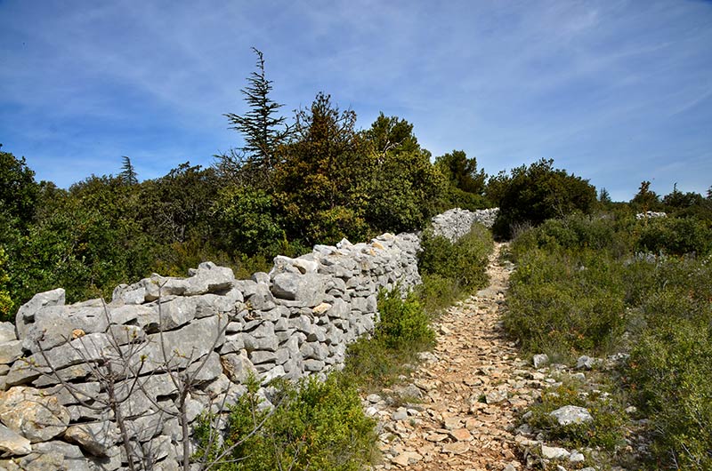
"Le Mur de la Peste" Lagnes et Cabrières
Vaucluse History: the Wall of Death
The Plague Wall is a wall built in the Vaucluse mountains to protect the Comtat Venaissin from the plague that struck Marseille and part of Provence in 1720-1722.
If the wall stretches for 27 kilometers of dry stone frame. many dry stone sentry greeted the guards. the route of the wall was by Antoine defines German architect, cartographer Carpentras, in his books Memory: I have made since 1700 and ordained in the Inguimbertine library:
"In 1720 I traçois from Saint-Hubert till Saint-Ferreol the boundaries between the Venaissin County and Provence, a line of 18,000 yards with 6,000 yards made with an earth parapet and a ditch in front, and 2,000 yards with walls made of dry stone. and thence along the Durance till its mouth in the Rhone and up the Rhone till Avignon whose length is 14 miles. "
In the Middle Ages the endemic plague foci were located in "scales" of the Levant. From the fourteenth century, the Black Death in the eighteenth century with the Great Plague,
the pandemic killed between 60 and 90% of patients. There was a great plague in a century.
The Great Plague
In May 1720 the "Black Death" was brought in Marseille by the Grand Saint Antoine, which the charterer, Alderman Estelle, despite a suspicious death reported by Captain Jean-Baptiste Chataud, insisted unlock its cargo market its silks at the Fair of Beaucaire which began on 20 July. The plague was not officially declared that 67 days after the ship's arrival.
In March 1721 to limit the spread of the disease as traffic restrictions fail to contain the kingdom of France the papal territories of Avignon and theVenaissin County choose to protect by health line materialized by a wall dry stone between the Durance and Mont Ventoux , and guarded day and night by French troops and papal preventing any passage. The people were thus requisitioned for its construction, the wall should prevent any relationship between the Comtat Venaissin and Dauphiné still spared.
Despite the natural barriers that represented the Durance, the Rhone, the Verdon, Var, Eygues and the Orb, to which was added the "Wall of Death", it has been calculated that the epidemic was moving 45 kilometers per month in populated area, with differences of 35 to 50 km / month. But if the plague struck the Alpine foothills and Gevaudan, it did not exceed Orange in the Rhone valley and stopped at the gates of Saint-Genest-de-Beauzon near Largentière.
The plague reached Apt , September 25, and Carpentras 24 October 1720, where we exhibited the relics of St. Siffrein and the Holy nail to keep the plague. A year later, Méthamis , 21 September 1721
There were 126,000 deaths in Provence, Languedoc and Comtat. In Provence, 81 communities were affected and a population of 293 113 inhabitants, there were 105 417 deaths (36%); in the Comtat, 6 communities, 36 641 inhabitants and 8 062 deaths (22%); Languedoc, 84 communities, or 12,597 deaths per 75,377 inhabitants (16.7%). Marseille, the first hit, lost half of its population, ie 50 000 deaths.
In 1723, the wall has no health benefit, and reused the stones for other constructions. Since 1986, a restoration and improvement campaign is in place through the association "Dry stone in Vaucluse". You can see the wall between Cabrières-d'Avignon and Lagnes , as well as Murs . Today, nearly six kilometers have been restored.

